This posting will highlight five maps of the Second Avenue Line - one new one and five old ones.
The first map, embedded below, is a new multimedia map of Phase I of the Second Avenue Subway. It was created using Google Maps, a web application and technology service.
Note:
It's much easier to view and work with this map using a larger image.
To view the larger image just click on this link:
Second Avenue Subway, Phase I
The map shows the approximate location of the planned stations, entrances, and ancillary buildings on the route.
It also shows the approximate location of the tunnels that were built back in the 1970s as well as the location of the last remaining car of a ten-car prototype train set that was purchased in 1949 for the Second Avenue Subway.
Note that you can click on any of the objects on the map for further details related to that object -- including an architectural rendering of each of the station entrances and ancillary buildings. (with a few exceptions)
Most of the information that has been detailed on this map was sourced from one or more of the presentations that the M.T.A. made to Community Board 8's Second Avenue Subway Task Force over the past few years.
Alternatively you can click on one or more of the signs shown below to jump directly to the detailed map for each future station.


These signs were produced for me by
the Brooklyn-based firm Underground Signs.
Underground Signs is in the business of creating custom and replica New York City Subway signs: made-to-order, using authentic metal construction. They are officially licensed by the M.T.A.
# #
The pictorial map shown below provides a street-level view of the Tunnel Boring Machine (TBM) launch box from high above Second Avenue at a given date and time.
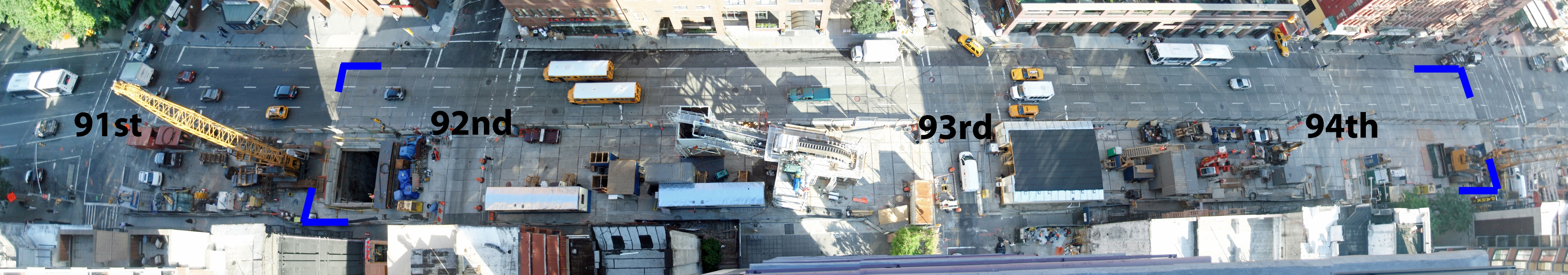
An aerial view of the TBM launch box
on 6/2/2010 at 7:35 a.m.
Courtesy of JSL
(click on the image for a high-definition view.)
# #
The map below is the the official M.T.A. map of the entire Second Avenue Subway line, as currently planned.

"New York City Subway Service with Second Avenue Subway Line"
Final Environmental Impact Statement
Second Avenue Subway Project, Figure 2-1
9/2003
# #
The two maps below, from 1939 and 1929, detail plans for expanding the New York City subway system around a core 4 to 6 track trunk line under Second Avenue.

Project for Expanded Rapid Transit Facilities
New York City Transit System
Board of Transportation of the City of New York
7/5/1939

Proposed Additional Rapid Transit Lines and Proposed Vehicular Tunnels
Board of Transportation of the City of New York
Engineering Department
8/23/1929
# #
Readers who wish to learn more about mapping of the Second Avenue line should visit this entry on Andrew Lynch's blog Vanshnookenraggen:
"The futureNYCSubway: 2nd Ave Subway Future"
# # # # #
The next meeting of the
Community Board 8 Second Avenue Subway Task Forcewill on Tuesday, October 12th at 6:30 p.m.
The meeting will be held at The New York Blood Center at
310 East 67th Street (btw. 1st and 2nd).
Agenda:
1. Construction Updates
2. Introduction to 72nd Street Cavern Excavation Contractor
3. Review of Ancillary Facility Architecture
4. 86th Street Ancillary Facility Design Update
5. 72nd Street Elevator Entrance
6. 72nd Street Station Ancillary Facilities – Rooftop Equipment Screens
7. Old Business
8. New Business
1 comment:
Thanks for the google map showing where the bits & pieces of Phase I construction fit into the streetscape. A good map makes all the difference.
One thing that I've been curious about since the digging was restarted, is why wasn't the 106 St station included in Phase I? Having this station as part of Phase I would have let them use all of the tunnels up to 120 St that were built in the 1970s.
Post a Comment